Felszereltség
A
RODEN Mérnöki Iroda Kft felkészülten alkalmazza a számítógéppel segített tervezést és a rajzgépes, mágneses adathordozón történő dokumentálás
technikáját, a szükséges hardware-ek és software-ek birtokában, magas szinten képzett kollégákkal.
A tervek készítése teljes körűen digitalizált (háromdimenziós modellben), kezdve a felméréstől a dokumentálás utolsó fázisáig.
A
RODEN Mérnöki Iroda Kft az általa készített kiviteli tervek alapján épített létesítmények kivitelezési fázisában is tevékenyen részt vesz,
engedélyezések, tervezői művezetés, építési geodéziai feladatok elvégzésével.
Mérnöki Irodánk filozófiája, hogy nem nagy létszámú tervezőcsoportokkal kell az adott feladatot - nehéz koordináció mellett - elvégezni, hanem
kevesebb, de széles ismeretekkel rendelkező - „problémaérzékeny”- szaktervezőkből álló, összeszokott team végezze a tervezői tevékenységet. Így a
legoptimálisabb a műszaki létesítmények megtervezéséhez szükséges korrekt és felelős előkészítés. Ennek megvalósításához nem hiányozhat az adott terület szakértőinek
bevonása, valamint az irányító tervezőmérnökök komplex szakismerete sem.
A felelősséget kiemelten kezelve a vezető tervezőknek el kell mélyülni az adott feladatokban, és útmutatást kell adni a tervező kollegáknak a részletmegoldások kidolgozásához.
Mindehhez elkerülhetetlen a szakmai, a technológiai és a számítógépes ismeretanyag bővítése, az emberfők kiművelése, az irányító szakértelem jelenléte, a
megfelelő eszközállomány megléte és folyamatos fejlesztése, korszerűsítése, ill. a folyamatos jelenlét az újabb mérnöki kihívások megoldásánál.
Az irodai fejlesztés folyamatos. A
RODEN a jól felszerelt Mérnöki Irodák sorába tartozik. A számítógépes háttéren túl korszerű eszközök segítik a
geodéziai méréseket, a helyszíni bejárást, valamint a tervezést, a munkaközbeni adatátadást, és a dokumentálást:
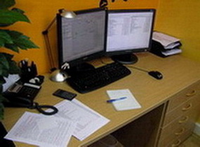
A tervező iroda számítástechnikai felkészültsége kimagasló, a szokásos irodai programcsomagokon (
Office XP, Windows XP) kívül általános és
speciális tervezőprogramokkal dolgoznak mérnökeink.
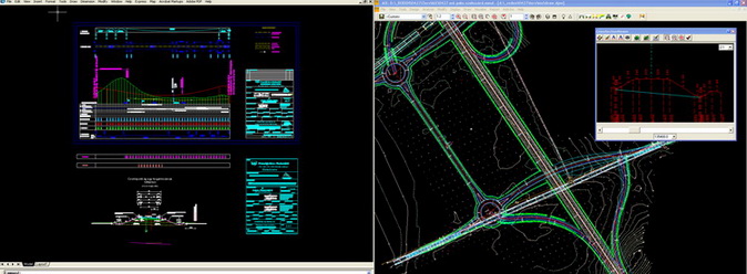
Általános tervezőprogramként az
AutoCAD-et használjuk, melyből cégünknél több mint 25 licensz van, továbbá 8 db
AutoCAD Civil 3D programcsomaggal is rendelkezünk.
Speciális tervezőprogramok közül cégünk profiljából adódóan az úttervezési feladatok megoldására a Bentley software a
MX v.2.6.3. (Moss) programrendszert alkalmazzuk (12 teljeskörű licensz),
ezenkívül a
MicroPISTE, AutoCAD Civil 3D, valamint a német fejlesztésű
CARD/1 System v.8.0. programcsomagot használjuk az úttervezésben.
Jelenleg 12 db (6 egyedi és 6 hálózati)
MX Professional (MOSS) tervezőprogram licensz van a cég birtokában.,
kiegészítve 4 db
MXROAD (extra úttervező) és 4 db
MXRenew (burkolatfelújító) modulokkal.
Ezen programok alkalmazásának előnye a mérhetetlen precizitáson és kitűzhetőségen túl a gyors változtathatóság, elemezhetőség, a döntési folyamat elősegítése és rendkívüli gyorsítása,
a flexibilitás és a hatékonyság.
A programok segítségével a teljes tér 3D-ben, több rétegben modellezhető, azonnali metszetek, tömegek, felületek lekérdezhetők, dokumentálhatók.
Továbbiakban
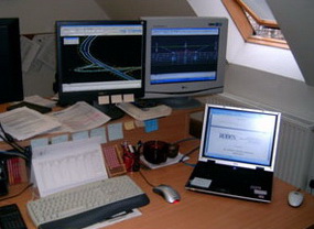
CAD alkalmazáshoz megfelelő konfigurációjú számítógépek irodai hálózata áll rendelkezésre.
Az 1Gbit-es hálózatot több redundáns és viruális szerver hozzá tartozó biztonsági mentő rendszerrel és Core2 Duo, Core2 Quad és Corel7-es,
nagy teljesítményű tervező számítógépek alkotják.
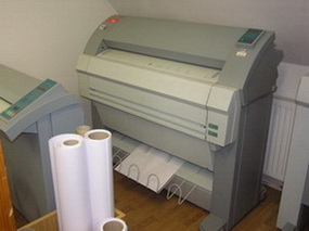
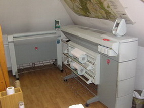
A hálózatot CD és DVD írók, A1 és A3 digitalizálók, A0+ scanner, A3-A4 lapolvasók,
HP tintasugaras A0+ és A1 színes plotterek (600-2400dpi), A0+ OCÉ laser és tintasugaras plotterek, nagy teljesítményű scannerek egészítik ki,
valamint 1db Miro Studio 7 digitalizáló eszköz, színes A3 nyomtatók, és további fekete- fehér laser nyomtatók, kamera, digitalizáló, lejátszó, felvevő,
és szerkesztő program, projector, Core2 Duo Notebookok alkotják az elvégzendő munkák műszaki hátterét.
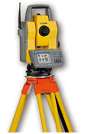
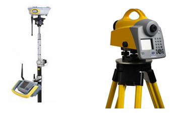
Terepjárók, szállító gépjárművek, személygépkocsik, Trimble totál mérőállomások (több típus), Trimble 4600 LS RTK GPS műholdas vevők, CB rádiók, Trimble R7-R8 GPS RTK vevőpárok,
Trimble DiNi 12T digitális szintező műszerek segítik a geodéziai munkánkat.
2006 évben egy háromdimenziós
Trimble GX3 laser szkennert vásároltunk, mely térbeli háromdimenziós felmérésre alkalmas, akár cm-es pontsűrűsséggel.
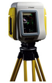
A
térszkenner alapvetően visszaverő felület (prizma) nélkül, lézer technikával (digitális kamerával kiegészítve) 3 dimenziós pontokat határoz meg a mérendő tárgy felületéről. A pontok sűrűsége a felbontás beállításával adható meg, akár fénykép minőségben is! Az eredmény egy 3D-s pontokból álló „pontfelhő”, egy vektoros digitális állomány, amely precíz, hagyományos eszközökkel elérhetetlen részletességű modellje a műtárgynak akár valós színekben is, így tökéletes alapja lehet a tervezésnek!
Az eszköz pontossága 100-150 méter hosszon 1 cm alatti, így a felmérés eredményeképpen igen pontos és részletes digitális (terep)modell állítható elő a legkülönbözőbb létesítményekről. Készíthetők szintvonalrajzok, térfogatmérések alapján köbtartalom számítások, ill. különféle térbeli elemzések is elvégezhetők. A műszer segítségével olyan tárgyak, felületek mérése is elvégezhető, melyek a hagyományos geodéziai módszerekkel nem, vagy csak nagyon körülményesen mérhetők.