Geodézia
A tervezési feladatok fontos alapja a jó minőségű geodéziai munka. Cégünk az évek során felépített egy geodéziai csoportot, valamint létrehozott egy geodéziával foglalkozó leányvállalatot,
a Mért Pont Földmérő és Mérnöki Irodát. Ezeknek a geodéziai egységeknek az elsődleges feladata cégünk tervezési feladataihoz szükséges, teljeskörű geodéziai munkák elvégzése.
Geodéziai tevékenységeink közé tartozik:
- Alappontsűrítések
- Tervezési térkép készítése
- Kivitelezéshez építési geodéziai feladatok
- Hídvizsgálati mérések
- Különböző célú egyéb felmérések, ellenőrző mérések
- Kitűzések
- Kisajátítási terv készítése
- Telekalakítási feladatok
Geodéziai egységeink természetesen külső megrendelésekre is végeznek feladatokat. Kivitelezők részére folyamatosan, de más tervező és egyéb szervezetek számára is rendszeresen dolgozunk.
Kivitelezéssel kapcsolatos munkáink során főbb kivitelező partnereink voltak:
- Betonút Zrt.
- Strabag Zrt.
- Vegyépszer Zrt.
- M6 Építési Kkt.
A geodéziával foglalkozó szakembereink közül:
- 6 fő geodéta mérnök
- 2 fő geodéta technikus
- figuránsok
Ezzel a szakember gárdával 6-8 terepi csapat tud egyszerre dolgozni, valamint többen az irodai feladatokat is el tudják látni.
A jó minőségű munkavégzés érdekében cégünk mindig a legkorszerűbb műszer-, és eszközparkkal rendelkezik.
Saját eszközök:
-
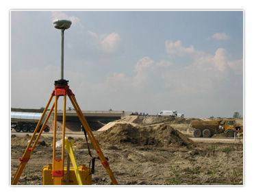
GPS: Trimble R7 – R8 RTK szettek
A kétfrekvenciás műholdas helymeghatározó rendszeren alapuló technológia alaphálózati feladatok megoldásakor ma már minden esetben, nyílt terepen pedig a részletmérési és a kitűzési feladatok esetén is a legkorszerűbb mérőrendszer.
-
Trimble GX 3D Lézerszkenner
A legkorszerűbb digitális felmérési technológia. Jelenleg az egyetlen olyan térszkenner, amely a geodéziai feladatokat is tudja (részletesebb leírás a honlapon külön található).
-
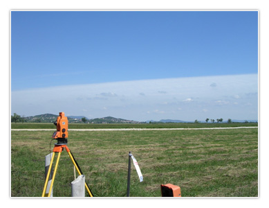
Intelligens mérőállomás és kiegészítő eszközei: komplett mérőrendszerek
(Geodiméter 510, Geodiméter 608 robot, Trimble 5602–, Trimble S6 mérő-robotok (Autolock), Trimble 5503)
Kiemelendő, hogy az S6 és a Trimble 5602-es műszer 2 másodperc pontosságú mérés el-végzésére alkalmas.
A nagy mennyiségű – elsősorban keresztszelvényszerű útburkolatoknál végzendő – felmé-réseknél hatékony a három robot kiépítésű műszerrel dolgozó mérőcsapat egyidejű munka-végzése.
A különböző részletmérési feladatokhoz olyan, a cégünk által kidolgozott és az eszköz-parkkal összhangba hozott felmérési technikákat alkalmazunk, amely gyors, biztosítja az előírt pontosságot és illeszkedik a tervezés folyamatához.
-
Szintezés: Trimble DiNi 12t, Leica 724 szintezőműszerekkel
A nagy pontosságú magassági meghatározásokhoz a Trimble DiNi 12t digitális szintező-műszer rendkívül gyors és a manuális hibaforrásoktól mentes munkát tesz lehetővé. Pon-tossága a felsőrendű szintezés követelményeit is kielégítik. A Leica 724-es automata szin-tezők az alsógeodéziai munkák kiváló segítői.
- Hagyományos mérőeszközök (szögprizma, mérőszalag, stb.), kiegészítő eszközök (pl. adó-vevő)
- Gépkocsik: terepjárók, kisteherautók, személyautók
- Hardverek (PC-k, laptop-ok, perifériák). A laptop feltétele a terepi – számítási, és szoftver hátteret igénylő – technológiáknak.
- Szoftver: Szakági – ITR, AutoCAD, MX, Irodai alkalmazások – MS Office
Nagyobb projektek megvalósításába bevont további mérőcsapatok komplett mérőeszköz felszerelése (mérőállomások, szintezők, hagyományos mérőeszközök, irodai infrastruktúra).
Tekintse meg Geodéziai referenciáinkat...»